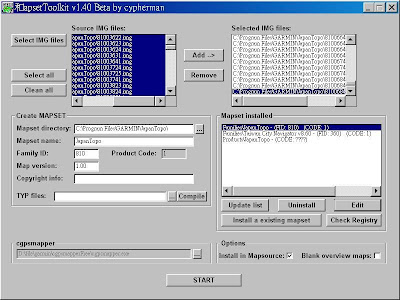
2008-10-30

鴻孕當頭


地點:政大

2008-10-26

到加州風洋食館(SKYLARK)慶結婚滿月


三商巧福盃路跑賽(台北站)

距離:8km
時間:35分22秒
名次:男132,男30-39歲70
費用:150

累計距離(km)...........時間
1.............................4'15''
2.............................5'00''
3.............................4'50''
4.............................5'00''
5.............................5'20''
6.............................5'20''
7.............................5'15''
8.............................1'40''


檢視較大的地圖


終點前的最後衝刺


就是他們,三商巧福的工作人員
我正仔細聆聽他們的發問


我指著Ann,直說Ann也對這個路跑賽很有想法
建議可以聘請Ann當他們的行銷公關啦~


哈!看我滔滔不絕的樣子
彷彿有「滿腹委屈」似的


今天是個happy running
因為今天又跑出個人最佳成績
繼上次忠孝獅子盃路跑之後,每公里再次跑進5分鐘以內
現階段我一直以達到此項目標為主
但是回家查了GPS軌跡追蹤器的記錄後,發現主辦單位將路程灌水
全程並沒有達8km,才7km多一點
著實讓大家參加了一個「快樂」的路跑

今天還發生了一件有趣的事
跑回終點後,竟然有四、五位像是大學生的人圍繞著我
詢問我是否願意接受採訪
有何不可呢?而且這樣顯得自己像是明星
哈哈...頓時阿Q的自我滿足一下
說來他們應該是路跑主辦單位的工作人員
因為他們有詢問我參加幾次三商巧福盃路跑賽、曾經參加幾次路跑賽、覺得這次路跑辦的如何、請我提出改善建議...等等
每一項提問我也很熱心的回答
優點方面我是說舉辦的場地在河濱公園非常美麗、空氣新鮮、贈品也很棒、開賽時採用分批進行的方式也可舒緩人潮
缺點像是開賽秩序凌亂、沒有老師帶領跑者做暖身操(這點他們有補充說第一組出發的跑者來不及做暖身操,但後來的跑者倒是有做到)、開賽之前會場不夠熱鬧、氣氛不夠嗨、飲水補給站太晚出現,希望能去程、回程各設置一處
想想我講缺點的時間好像比講優點的長
那時我突然覺得不好意思
不過他們態度還不錯,一直說沒關係
真是有趣的經驗

2008-10-24

阿娘威~我上雜誌了!


2008-10-22

GPS地圖

MapCenter: http://mapcenter.cgpsmapper.com/

GpsMapSearch: http://gpsmapsearch.com/

OSM: http://wiki.openstreetmap.org/index.php/OSM_Map_On_Garmin/Download

Rodrigo Moya: http://rodrigo.gnome-db.org/gps/garmin/

MalSingMaps: http://www.malsingmaps.com/portal/

SportTracks


1.安裝SportTracks: http://www.zonefivesoftware.com/SportTracks/Downloads/

2.安裝自己需要用到的外掛模組: http://www.zonefivesoftware.com/SportTracks/Plugins/

(1)下載Elevation Correction Plugin: http://www.zonefivesoftware.com/SportTracks/Plugins/plugin_detail.php?id=71
(2)下載GDAL Plugin: http://www.zonefivesoftware.com/SportTracks/Plugins/plugin_detail.php?id=70

(安裝這2個Plugin後,SportTracks會連到NASA的FTP伺服器,讀取裡面全世界的高度資料庫National Elevation Dataset (NED),這樣航跡資料就會有高度變化的數據了。)

(解壓縮後的檔案需放在SportTracks的Plugin目錄中,例如:C:\Program Files\Zone Five Software\SportTracks 2.0\Plugins底下)

(3)即時氣象
必須安裝SportTracks 2.0版,才能自動下載天氣資料
設定方法如下:
a.選擇左下方的Settings
b.按下Weather選項
c.於Location:空格處填上所在地名稱,如:Taipei, Taiwan

3.匯入GPS軌跡
凡GPS航跡檔為gpx、hrm、fitlog、hst、tcx等格式,均可匯入SportTracks。

MapSetToolKit


操作方法如下:
1. "Select IMG files". Note: MapSet Toolkit will only recognize .img files with a numerical filename. If you rename the file with a non-numerical name, it won't show up.

2. "Add". You can add multiple .img files as part of a single set of files.

3.Chose the same directory that contained the .img file as the "Mapset directory" to be used.

4. Assigned a name to the mapset, "Japan".

5. Chose a 4-digit "Product Code" number (ex: "8765") or "Family ID" (ex: "810"); the only limitation is that it not conflict with any other product codes (which are displayed in the "Uninstall Mapset" box at the right).

6. You can enter copyright info if appropriate, but it's not required here.

7. At lower left, chose the directory where cgpsmapper.exe is located (usually the C:\Program Files\cGPSmapper directory), and selected the cgpsmapper.exe file.

8. The "Convert (Product>Families)" section was left blank; more information about Family ID and TYP files is available in the cgpsmapper manual.

9. Checked the box marked "Install in MapSource". Checking "Blank overview maps" will eliminate the map preview in MapSource, but I can't think of a good reason to do that.

10. Clicked "Start", and shortly thereafter got a message box saying "Convert termined" (sic).

11. In the "Uninstall Mapset" section, there's now a new listing for the added map.

MapSource


如果遇到無法開啟的狀況
可用以下方式重灌:

1.uninstall MapSource

2.開始 / 執行 / regedit

3.到MACHINE / SOFTWARE / GARMIN / 底下全部刪除 (把MapSource刪除)

4.到USER / SOFTWARE / GARMIN / 底下刪除MapSource (留COMMON)

5.重灌MapSource

Time Machine X


選擇「Cancel」


先將「tk1檔」轉換成「tk2檔」才可以編輯


一個tk1檔轉出三個tk2檔


編輯gps軌跡


輸出報告


可將編輯後的tk2檔轉成其他種類的檔案